
Storms dump 8.2 inches Friday alone
In late April and all through May, rain locally was as scarce as 70-degree day in July.
Last weekend, however, went a long way to make up for it.
Thunderstorms spawned by the remnants of Tropical Storm Arthur brought heavy rain and high wind to the area Friday and again over the weekend.
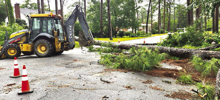
Nearly 10 inches of rain fell in Waycross from late morning Friday, June 19 through Sunday evening, June 21 according to Wunderground.com, as cells of the storm moved east from its origin early last week off the coast of Texas. Wind gusts of nearly 40 mph accompanied the worst storms, which flooded streets and sent limbs and entire trees in a couple of cases to the ground.
The worst of the storms hit late Friday morning and continued intermittently until around 5 p.m. The bulk of the weekend’s 9.7 inches of rain — 6.8 — fell between 10:15 a.m. and 2 p.m., Friday.
That storm taxed storm drains on city streets and and sent canals out of their banks for a short period around mid-day Friday. Similar amounts of rain fell June 19-21 in surrounding counties leading to flood watches and warnings from the National Weather Service that finally were canceled Monday, June 22.
Waycross Public Works Director Matt Elwell said his department had crews on the streets handling issues Friday and Sunday.

“We had some temporary street flooding that closed some sections of road for a time, and two large trees fell blocking roads that we had to remove, both in the Cherokee Heights neighborhood,” Elwell said Monday morning.
Friday’s first storm sent the community’s Juneteenth Festival from outdoors in Bailey Street Park to inside C.C. McCray City Auditorium with a start time delayed from noon to 4 p.m. The senior farmer’s market that was part of the festival program was rescheduled for noon today (Wednesday, June 24) at the park.
Attempts were unsuccessful Monday to reach Ware County Manager James Shubert or someone in the Ware County Emergency Management Office for a report on any issues in the county caused by the storm.
Total amount of rain for the 24-hour period Friday was 8.2 inches. Storms also hit June 20 and 21, but were shorter and less intense.
A total of .7 of an inch fell for the 24-hour period, June 20, but it all came in one storm from 7 to 9 p.m. Rain June 21 led to a 24hour total of .8 inches, but again all fell in showers between 4:30 and 9 p.m.
The forecast for the week ahead calls for mostly dry conditions with some of the hottest day temperatures of the season. Thursday and Friday are the lone days in the next week with chances of rain more than 40 percent.
Daytime temperatures, however, are expected to climb into the mid- to upper-90s, which combined with higher humidity, will put heat indices in the 105-110 range. Lows at night aren’t expected to fall below the mid-70s, which means a rapid warm up the following morning.
Advance forecast for the Fourth of July weekend calls for much of the same in temperature, but with a 40 percent chance of thundershowers July 4 rising to 50 percent the following day.