
A severe thunderstorm rolled through Ware County Saturday afternoon caused power outages, flooded roadways, toppled trees, upended unsecured structures and damaged the framing of a building under construction, authorities said.
The June 13 storm dropped more than an inch of rain in less than an hour and produced wind gusts approaching 50 mph at its peak, according to National Weather Service data. Radar indicated the storm, which was accompanied by severe lightning, formed around 3 p.m. prompting a thunderstorm warning for the area.
The result was heavy wind and rain knocking out power in some locations, flooded some roads, streets and some parking lots before passing through.
“It was cloudy and the next minute it was stormy,” said one man, who was caught at work in the storm and requested anonymity. “It was to the point where you couldn’t see, not even a car in front of you ... there was almost no visibility. You could visually see the wind going around cars ... it was bad.”
Coincidentally, the driver lived on Brunel Street across from the building framework damaged by the wind.
Waycross Fire Department Chief Jim Blackburn said Monday his personnel handled six storm-related calls, all for downed trees and power lines. One of the trees fell on a truck in the Hatcher Way Apartments parking lot, he said.
Blackburn said a blown transformer on Central Avenue resulted in the loss of power in that area. No injuries were reported as a result of the storm, Chief Blackburn said.
Waycross Public Works Director Matt Elwell said his crews were out, but infrastructure issues were minimal.
“Overall, we were pretty lucky,” Elwell said Monday. “There was some damage to street signs and traffic signals, but they were both on state routes so it was handled by GDOT (Georgia Department of Transportation).
“As for the city, we had some temporary street flooding at the peak of the rain but other than that we were pretty unscathed.”
The bulk of the flooding was in the Memorial Drive area, with a portion of the parking lot at Walmart flooded during the height of the storm.
“The water on the roads was bad,” said the driver, who lived on Brunel. “People were having to kind of speed through it to get past, or else they probably would’ve gotten stuck or at least felt floated away — one or the other.”
The building framework that was damaged was at the site of the former Flanders Meat business. Chief Blackburn said a new food service distribution center is being built there.
The high winds buckled the front side of the steel beams adjacent to Brunel Street, pushing them out toward the road after bolts at the base broke away from the concrete. Two sides were not damaged, while no steel structures had been erected on the back side.
The area received another dose of heavy rain, wind and lightning from a thunderstorm early Sunday evening.
According to the forecast, the area is likely to see a repeat of the weekend scenario the rest of this week. Temperatures are predicted to be in the upper 80s and low 90s with lows in the low 70s through the weekend, with a chance of thunderstorms each day.
Staff Writer Rick Nolte contributed to this report.
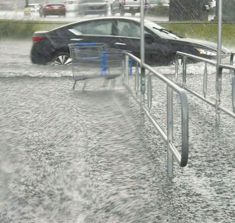
A car moves slowly through the flooded parking lot at Walmart Saturday afternoon near the end of the thunderstorm that dropped more than an inch of rain in less than an hour. SPECIAL PHOTO